The following list provides checkpoints often referred to by Guatemala radio controllers.
When flying in Guatemala you are talking to a controller almost all the time. There are only a few exceptions. In mountainous areas you might not be able to communicate properly, for example. Over the lake Izabal, you would be making position reports to the Aeroclub Rio Dulce Unicom. The map shows the coverage areas and frequencies of ATC controllers and the typical hand-offs shown as red dots. Further below on this page you will find these hand-off points in reference to GPS coordinates and VOR radials.
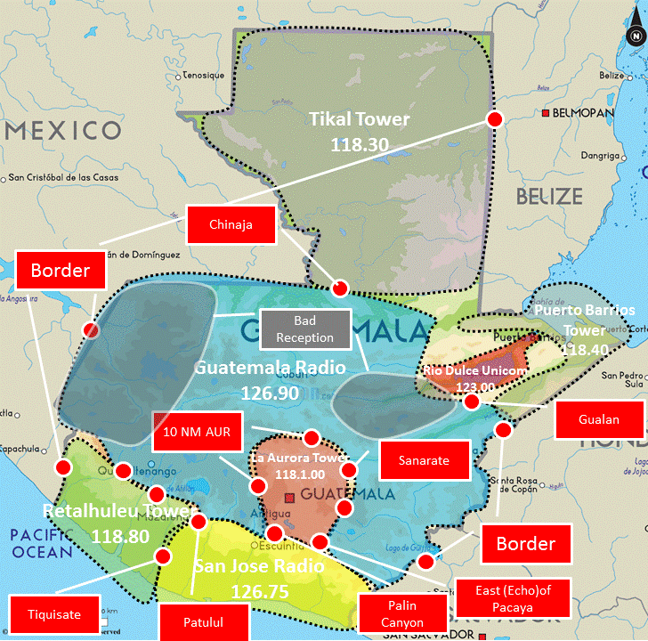
[The underlying map was borrowed from Elizon]
| Waypoint Name | Coordinates | VOR Info |
|---|---|---|
| Canyon de Palin | N 14° 24.285 W 090° 41.364 |
VOR AUR 220° 15 NM VOR SJO 15° 30 NM |
| Echo de Pacaya | N 14° 19.835 W 090° 28.118 |
VOR AUR 165° 16 NM VOR SJO 039° 33 NM |
| Sanarate | N 14° 47.887 W 090° 11.824 |
VOR AUR 55° 23 NM VOR RAB 125° 20 NM |
| Patulul | N 14° 23.806 W 091° 11.768 |
VOR SJO 320° 35 NM |
| Tiquisate | N 14° 17.345 W 091° 22.057 |
VOR SJO 300° 37 NM |
| Chinaja | N 15° 59.805 W 090° 17.695 |
VOR RAB 005° 60 NM VOR TIK 200° 60 NM |
| Gualan | N 15° 06.833 W 089° 21.520 |
VOR IOS 225° 58 NM |
| Paztun | N 14°40’41.7″ | VOR AUR 282° 29 NM |
Pingback: Common Guatemalan air traffic controller checkpoints | Guatemala Skies