The Downloads sections objective is to be able to share some information in a convenient format. You will find files with many landing strips in Guatemala that you can import into your GPS, checklists for you GPS, useful information for your flight in a practical format and hopefully more with time.
Guatemala_airports_and_fields.gpx |
Please use the files for GPS devices with extreme care! I have tested the functionality on a GPS Garmin aera 795. There are posts in the Internet claiming that these files can potentially break a device.Content: – Guatemala airports – Grass runways – Navigation waypoints – Emergency landing sites Installation Instructions On a Garmin aera 795 you simply place the waypoint or checklist file on the memory card. The information is available a couple of seconds after you plug in the SD card. |
GuateAiports.dup |
The same waypoints in the DUP format. This file was created from a GPS XML file as specificed on the DynonDocs Wiki and then transformed with the tool from the same site.[download DUP file] |
checklists.ace |
The Garmin 795 allows you to manage checklists in your device. These checklists can be customized. This ACE file contains a non-official checklist for the Cessna 172 XP. The checklist was generated with the Garmin Checklist Editor. |
GuatemalaGAInfo2Go.pdf |
Guatemala General Aviation Information To Go Booklet When printed, the letter size paper can be folded twice to a pocket size convenient format. This version contains the following: – Guatemala Radio Frequencies – Emergency Transponder Codes & ATC Light Signals – MGGT airport information – Basic routing information Pacific & Atlantic |
Cessna172XP19772Go.pdf |
Cessna 172 XP 1977 Checklist & Guatemala General Aviation Information When printed, the letter size paper can be folded twice to a pocket size convenient format. This version contains the following: – Cessna 172XP 1977 Checklist – Guatemala Radio Frequencies – Emergency Transponder Codes & ATC Light Signals – MGGT airport information – Basic routing information Pacific & Atlantic |
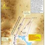
 MGGT Visual Approach SW.jpg |
This information was provided by AIP. I recommand adding the waypoints into your GPS. The GPS download files will be updated accordingly. La Aurora Tower told me not so long ago, please continue approach as published. You should get familiarized with this approach. This is not the authoritive source, please make sure to check with the offical institutions. |
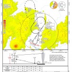
 MGGT Instrument Approaches.jpg |
This information was provided by AIP. Interesting even for non-instrument rated pilots. |

Pingback: Shared approach information from AIP | Guatemala Skies