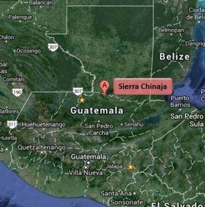
You didn’t know where Chinaja is located? You wonder why this should interest you?
Sierra Chinaja is located in the north of Alta Verapaz very close to the border of the Peten region. I had never heard of Chinaja before until this Sunday, when I was asked by Guatemala Radio to report when in area of Chinaja. This was a visual flight to Tikal. Chinaja is where radio communications are handed over from Guatemala Radio to Tikal. Guatemala radio was kind enough to provide the position of Chinaja (90 NM north of MGGT).
There are several radio communication hand-over spots in Guatemala. Many of them a referred to as the closest landmark / village: Canyon de Palin, Echo de Pacaya, Patulul, Tiquisate, Sanarate and now Chinaja. Personally I am not a big fan of it, since it leaves pilots not familiar with the area clueless about the positions. I have learnt to fly in Guatemala, so pilot-wise, I am local and I still have not heard about Chinaja before. I would bet that local pilots, when asked, would provide quite different coordinates for the above hand-over positions. Most probably there are even pilots that don’t have a clue about the location of the checkpoint and won’t ask.
Why wouldn’t we report on radials and distances from airports and VORs? Wouldn’t that be much more effective?
At the very least, we should publish Guatemala’s radio communication hand-over checkpoints. I will provide what I know soon.
Oh…. and I did check out Chinaja on Google Maps.

