Soft field landing and take off for real

I don’t know about you, but during my training in the Northeastern US, I learned to fly around NYC and later I was based out of DCA, I was told how to deal with heavy ATC traffic, how to manage icing, how to land on snow contaminated runways, and also how to land and take off from soft and short fields. But given that there are not too many real grass fields out there in the NE USA (and that insurance does not like you to train on grass), training was mostly simulated. Once I got to Guatemala however I was faced with a real challenge: Land and take off from a grass strip… My first reaction was: Oh my God! Here we go with my nice Mooney… what should I do? I must say that I was really scared. I already saw myself calling my insurance telling them that my plane was totaled…

So after taking off from La Aurora and flying East of the Pacaya Volcano at 6500 feet to the South, I started descending to 1000 feet to join the pattern at Iztapa, a very nice grass field where the local Aeroclub runs a Hotel and a Restaurant. I joined the left downwind for Runway 27, throttled back to 17 MP, GUMPS check (Gas, Undercarriage, Mixture, Prop, Safety) and reduced speed to 100 mph. Radio calls! In Spanish! 45 degrees over my left shoulder time to turn base (don’t forget flaps), 90 mph…. what a beautiful scenary… Suddenly my GPS shouts at me: Terrain, Terrain…. pull up, pull up (what the heck is going on), of course the airport is not in the database… So shut up Garmin… ok let’s turn final full flaps, reduce speed to 80 and then 75 mph and I see a green field… delimitated by some white cones. And I should land there…??? No way… Let’s not forget softfield procedure! keep the plane flying, keep it flying… stall horn, and bump… I landed… keep the yoke back… radio call and I cleared the field….

You may ask me: what was different? Well not much… but that statement comes after the fact… I can assure you that I was soaked…

Here is the video of that flight. I hope you enjoy it as much as I enjoy flying around here.

Posted in Uncategorized | Leave a comment

Flying in Guatemala

Guatemala is one of the most beautiful countries to fly in. The scenery is fabulous, where in the world can you fly watching two active volcanos at the same time, only in Guatemala… The flying community in Guatemala is extremely welcoming and nice, and you will be invited to join fly inns, 100 US$ breakfast as soon as you arrive.
However, there are some issues that you have to keep in mind:
a. Geography: Guatemala is a very mountainous country and there is no VFR chart of the area. So before you venture yourself out there, be aware that there are many granite walls that you should avoid. Also density altitude and turbulence can be challenging. Check runway lengths and the capacity of your bird to tackle the altitude. So first recommendation, before you fly solo VFR, fly with somebody who knows the area. Also a GPS with terrain features is always a plus.
b. Weather: As in any mountainous area, weather and winds are always an issue. Winds are gusty and strong and the weather can change from one moment to the other. During certain times of the year visibility can be very low…
c. Avgas availability: Avgas is ONLY available in Guatemala City. So plan accordingly.
d. You always have to file a flight plan. Regardless if you fly VFR or IFR.
These are some issues that come to my mind. But I am sure that there are many more that may be useful. So let’s start a discussion about this.

Posted in Uncategorized | 2 Comments

Iztapa can get busy

Iztapa is a popular destination for members of the Aeroclub. On week-ends you will have the runway on your own most of the times and on normal week-ends you might find one other pilot in the pattern. Iztapa is usually far from being crowded but there are days and hours where it can get just a little bit busier than that. Not long ago, we were 4 single engine airplanes, an ultralight and an experimental somewhere on the runway, in the pattern or arriving. This was not for the Iztapa airshow by the way, just an ordinary Sunday morning. Additional complexity arises from training flights making full stop landings on runway 27 and taking off from 09 (against the traffic flow). Communication that day wasn’t perfect so I made a note to myself to read up on procedures and communication best practices for un-towered airports such as Iztapa.

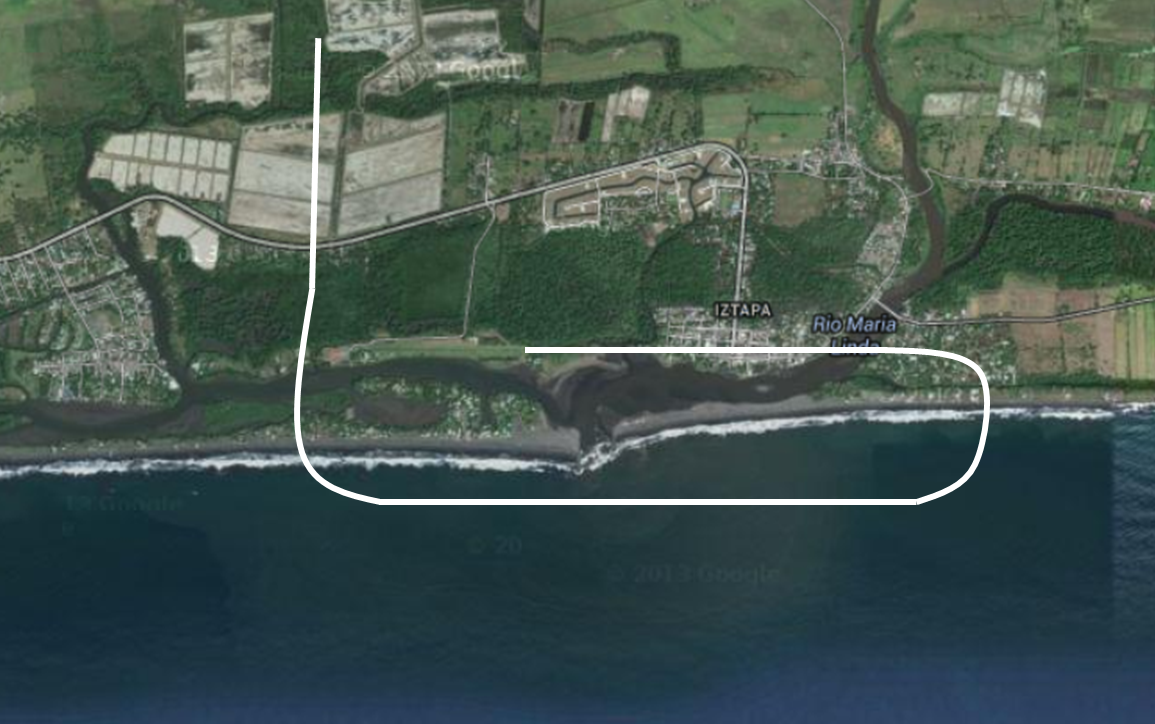
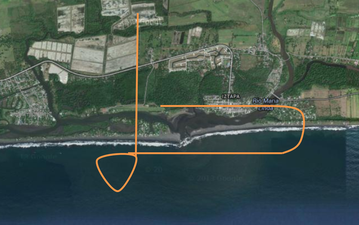
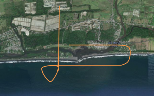
Let’s start with the traffic pattern and how to enter it. When coming from the North I would usually fly over the field at threshold of runway 09 and then turn left over the Pacific to join the left downwind for runway 27. Iztapa uses the standard left-turning traffic pattern. Therefore it’s all left turns to left base and then to final to 27.

IztapaMostCommonNorthEntry

I believe that approach is acceptable. Although I remember from a flight with an instructor in the US that he recommended to overfly the runway mid-field 1000 ft above pattern altitude, then tear drop to join the downwind leg.

IztapaByTheBookNorthEntry

I will try this by-the-book approach next time around and see if it provides benefits when it comes to visibility of other planes in the pattern etc.

In the early morning, calm conditions usually prevail in Iztapa. A full stop landing on 27 with a subsequent takeoff from 09 is common practice. I can’t see anything wrong with that and I have done it myself many times. I would probably discontinue full-stop landings and switch to touch and gos if more planes stay in the pattern. Now taking off from runway 09 while others are in the pattern for 27 is a little different. I strongly believe that in this case you should not make a right turn after takeoff (which happened that day). I would compare that with driving into a one-way street with your warning lights one, just that airplanes don’t have warning lights. The normal procedure is a 45° left turn after takeoff before joining the heading to your destination. Even if you want to teardrop back to make another landing I would recommend a 45° left-turn after takeoff before turning back right and joining final.

I have never seen anyone arriving from the south (would be interesting). Eastern and western arrivals are common. East can be flown direct, although I personally prefer fly upwind, then cross the runway to left downwind. That allows me to get a glimpse on the runway. When coming from San Jose, joining left downwind directly is fine.

Now let’s talk about communications. San Jose radio request to switch frequency with Iztapa at sight. Upon arrival everyone should report rough situation in respect to the runway. Personally I don’t think call signs add value. I would just call out the type of plane which gives others a feel for speed. All this together I would do the call like this.

“Iztapa trafico, Cessna Centurion, 5 millas norte, 2000 pies, para un aterizaje 27, voy a sobrevolar la pista para incorporarme con el viento izquierda 27”

The FAA recommends calling out the traffic name at the end also. The reason is potentially overlapping frequencies. It is safe to say that that shouldn’t be a problem in Iztapa, it doesn’t hurt either. For you to decide.

From there you should report every time you are turning within the pattern. The reason is that turning planes can be spotted much easier.

“Iztapa trafico, Cessna Centurion, incorporandome con el viento izquierda 27”

“Iztapa trafico, Cessna Centurion, virando base izquierda 27”

“Iztapa trafico, Cessna Centurion, virando final 27”

“Iztapa trafico, Cessna Centurion, dejando pista libre”

That last one is a courtesy to the plane coming after you. If he knows that you are off the runway, he can concentrate on the landing and doesn’t have to check if you have cleared the runway yet.

If all pilots would follow the above guidelines, Iztapa would be a piece of cake even at those rare busy days. And I am fine with ordering your “100 Dollar Desayuno Chapin” on days where the frequency and the area is less crowded.

Please share your views!!

Posted in Uncategorized | 3 Comments

Visibility Reminder

These days visibility has not been great, so I made sure to revisit key points here in Guatemala.

Visual meteorological conditions (VMC) at the La Aurora Airport require a cloud ceiling of at least 1,500 ft and visibility of at least 5,000 meters.

The METAR is a good start. Considering the below…

MGGT 061200Z 16003KT 1000 FG OVC002 15/15 Q1025 A3027 APCH CLSD

Overcast or cloud ceiling at 200 ft and 1000 meters of visibility, so definitely Visual Meteorological Conditions (IMC). I always have to remind myself that visibility in METAR reports is provided in meters (if not otherwise stated). That must be the only data provided in meters. Cloud altitudes are stated in ft above ground. Knowing La Aurora is at 4952 ft altitude this seems pretty obvious. For less obvious situations, it is important to remember. FEW018 at La Aurora represents clouds at 1800 ft above ground or roughly 6,800 ft indicated altitude.

The best way to determine visual conditions remains taking a look. The visibility panoramic picture can help… The “El Reformador” tower is 3700 meters looking north to end of the runway 02. If you can see the tower, good. But you will need a little bit more visibility. If the mountains to the east are not hidden by clouds and you can spot the antennas, you have almost 6000 meters visibility. From a minimums perspective, it is visual. No need to say that your go/no-go decision needs much more considerations.

Good visibility everyone!

Posted in Uncategorized | 3 Comments

What is the matter with position reports of some fellow pilots

Not long ago on a flight from Iztapa to La Aurora there was another plane flying the exact same route and altitude. Not being sure if the plane was faster (it took off from Iztapa a couple of minutes later), I reported positions several times. At one point I reported being 20 NM DME from La Aurora. To my surprise the other plane reported 18 miles indicated GPS distance from La Aurora. I was worried, thinking that the other plane must have overtaken me much quicker than I anticipated. I asked because I suspected we were awful close, when the other pilot said he was over Caobanal. Caobanal is more in the 30 NM distance, definitely not 18 NM. We were not even close. Similar thing happened 10 NM to La Aurora… I am pretty confident, that my reading was correct (3 GPS and DME wouldn’t lie, would it?). So I have to wonder, what was going on in the other plane? Faulty equipment? No reading glasses on board? Does the pilot use some estimate of where he will be when his distance report is completed? I have also heard about pilots intentionally reporting being closer to La Aurora to be queued first. First come first serve…

Any of the above seem dangerous and irresponsible to me. Guatemala traffic is concentrated to pretty narrow routes in some areas and every pilot should be able to report his location accurately.

The question remains in my … “What is the matter with position reports of some fellow pilots?”

Posted in Uncategorized | 3 Comments

Common Guatemalan air traffic controller checkpoints

As a follow-up to the post about Chinaja checkpoint, here is list of checkpoints that Guatemala air traffic controllers commonly refer to.

Posted in Uncategorized | Leave a comment

Chinaja

You didn’t know where Chinaja is located? You wonder why this should interest you?

Sierra Chinaja is located in the north of Alta Verapaz very close to the border of the Peten region. I had never heard of Chinaja before until this Sunday, when I was asked by Guatemala Radio to report when in area of Chinaja. This was a visual flight to Tikal. Chinaja is where radio communications are handed over from Guatemala Radio to Tikal. Guatemala radio was kind enough to provide the position of Chinaja (90 NM north of MGGT).

There are several radio communication hand-over spots in Guatemala. Many of them a referred to as the closest landmark / village: Canyon de Palin, Echo de Pacaya, Patulul, Tiquisate, Sanarate and now Chinaja. Personally I am not a big fan of it, since it leaves pilots not familiar with the area clueless about the positions. I have learnt to fly in Guatemala, so pilot-wise, I am local and I still have not heard about Chinaja before. I would bet that local pilots, when asked, would provide quite different coordinates for the above hand-over positions. Most probably there are even pilots that don’t have a clue about the location of the checkpoint and won’t ask.

Why wouldn’t we report on radials and distances from airports and VORs? Wouldn’t that be much more effective?

At the very least, we should publish Guatemala’s radio communication hand-over checkpoints. I will provide what I know soon.

Oh…. and I did check out Chinaja on Google Maps.

Chinaja

Posted in Uncategorized | Leave a comment

A new webcam

This new webcam was created for Guatemala Skies exclusively. The camera points to the south, including both routes to the Pacific (Canyon de Palin & Echo de Pacaya). The picture will update every 5 minutes.

Hopefully this webcam will proof useful. Happy watching!

Posted in Uncategorized | Leave a comment

Density Altitude Tool now global

I have made several improvements to the Density Altitude Tool. It now works many global airports around the world. I believe this is a very useful tool and you find it useful too.

Enjoy!

Posted in Uncategorized | Leave a comment

Visual Departure Raymo

Recently on a flight to Coban Guatemala tower requested to follow the Visual Departure Raymo procedure. I have tried to find the published departure since then with no success. One hint I was able to find were visual departures where the missed approach fix Raymo is located on the 10 NM DME arc on radial 350 and is supposed to passed at 10,000 Feet. The tower did provide the following information, after acknowledging that I was not familiar with that departure.

“Visual Departure Raymo”
– Intersept 345 VOR
– Stay below 8,000 Feet
– Until 11 NM DME

After that I was cleared to climb and fly directly to Rabinal/Coban.

The above information provided by the tower and the instrument departure match in the sense that they provide 2,000 Feet traffic seperation.

Have you heard of this or other visual departures?

Posted in Uncategorized | 2 Comments